Wednesday 29 July 2026
Stage 2
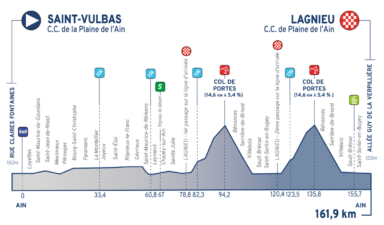
Saint-Vulbas
Lagnieu

Live TV starts :14h45
| Distance |
162 km (101 mi) |
|---|---|
| Climbing |
+2,304 m (7,559 ft) |
| Type |
Hilly |
| Délais (estimated) |
n/a
|
| GPX file | Download |
| Timetable (estimated) | PDF (64.80 KB) |
 Yellow Jersey
 Blue Polka Dot Jersey
 Green Jersey
 White Jersey
Located 35 minutes from Lyon and an hour and a half from Geneva, Saint-Vulbas (Ain) has successfully turned this paradox to its advantage, achieving a perfect harmony between lush wooded areas and the intricate floral displays characteristic of the local countryside. The village was once the site of a major Gallo-Roman settlement, as evidenced by numerous visible remains. The municipality has successfully showcased its natural heritage and preserved its identity alongside the Bugey nuclear power plant and the Plaine de l’Ain industrial park. The year 2024 marked a significant milestone for our municipality and for cycling, as we hosted a Tour de France stage finish. This prestigious event shone a spotlight on Saint-Vulbas, highlighting its dynamism and exceptional quality of life. Holder of the “4 Flowers” label for over 20 years, Saint-Vulbas is part of the “4-Flower Towns and Villages of Ain” circuit. Numerous initiatives promoting sustainable development and biodiversity have been implemented, including sown fallow land (since 2016), tit and swallow nesting boxes decorated by local children, and the provision of compost. An eco-grazing program using donkeys and Solognot sheep has also been in place around the Bugey power plant since 2017.
The town of Lagnieu is located in the south of the Ain department, on the right bank of the Rhône, 41 km from Lyon and 37 km from Bourg-en-Bresse. Nestled against the foothills of the Jura Mountains (the Bugey region), it lies within the natural region of the Ain Plain—which also gives its name to the industrial park situated about ten kilometers west of the town. Its territory covers 2,725 hectares, with a population density of 264 inhabitants per square kilometer, and includes the hamlets of Charveyron, Proulieu, and Posafol. With its extensive infrastructure and array of sports and cultural facilities—such as the Church of Saint John the Baptist and the Château de Montferrand—Lagnieu serves as a hub for around ten surrounding municipalities. The town’s vibrant community life is reflected in its numerous associations, fostering an environment where it is pleasant to live and socialize with a genuine “village” feel. Lagnieu also serves as a starting point for many hikes leading up to Mont Bramafan and the cross that bears its name; from the summit, one can enjoy a panoramic view of the town and the Ain Plain.